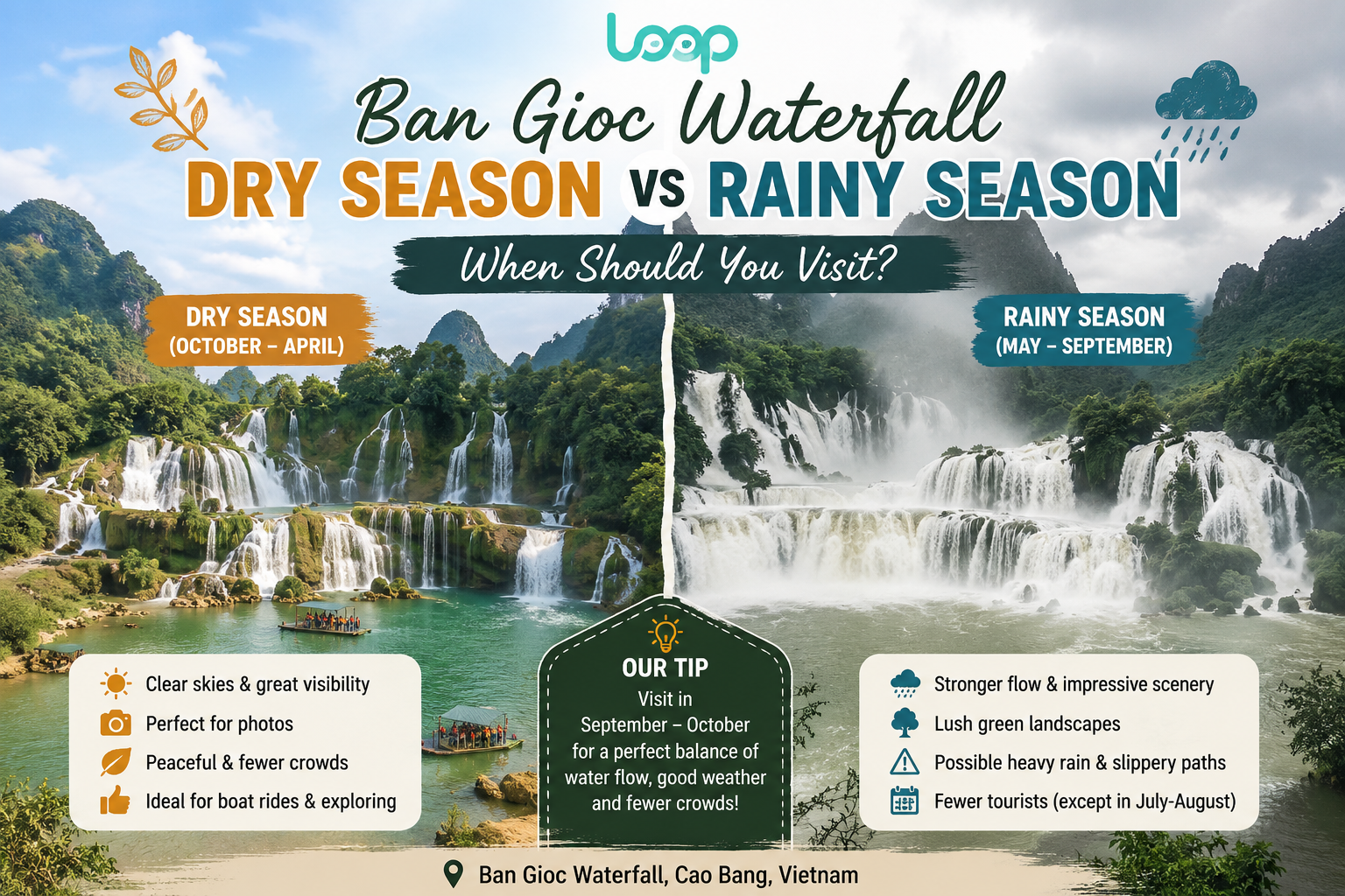
When traveling along the famous Ha Giang Loop in northern Vietnam, one of the most unforgettable stretches of road is the Tham Ma slope. Known for its breathtaking curves and scenic beauty, Tham Ma slope is more than just a challenging mountain road - it is a cultural and photographic highlight of Ha Giang. In this article, we will explore the history, significance, and experiences that make Tham Ma slope a must-visit destination for adventurers and travelers.
Recommended Tours for You:
Where Is Tham Ma Slope?
Tham Ma slope is located on National Highway 4C, the route that connects Ha Giang city to Dong Van and Meo Vac. It lies within the UNESCO-recognized Dong Van Karst Plateau Geopark, a region famous for its rugged limestone mountains and cultural diversity.
This slope is often considered one of the first real challenges travelers face when beginning the Ha Giang Loop. Its steep gradients and sharp turns demand both caution and skill from drivers, especially those riding motorbikes—the most popular way to experience Ha Giang.
The Meaning Behind the Name “Tham Ma”
The name “Tham Ma” has an interesting origin. In local dialect, it refers to “testing the strength of horses.” In the past, this slope was used to check whether a horse was strong enough to work on the plateau. If the horse could climb Tham Ma, it was considered capable of carrying loads and enduring the harsh mountainous terrain.
Today, while horses are no longer the main mode of transportation, the name remains as a reminder of Ha Giang’s history and traditions.
Why Is Tham Ma Slope Famous?
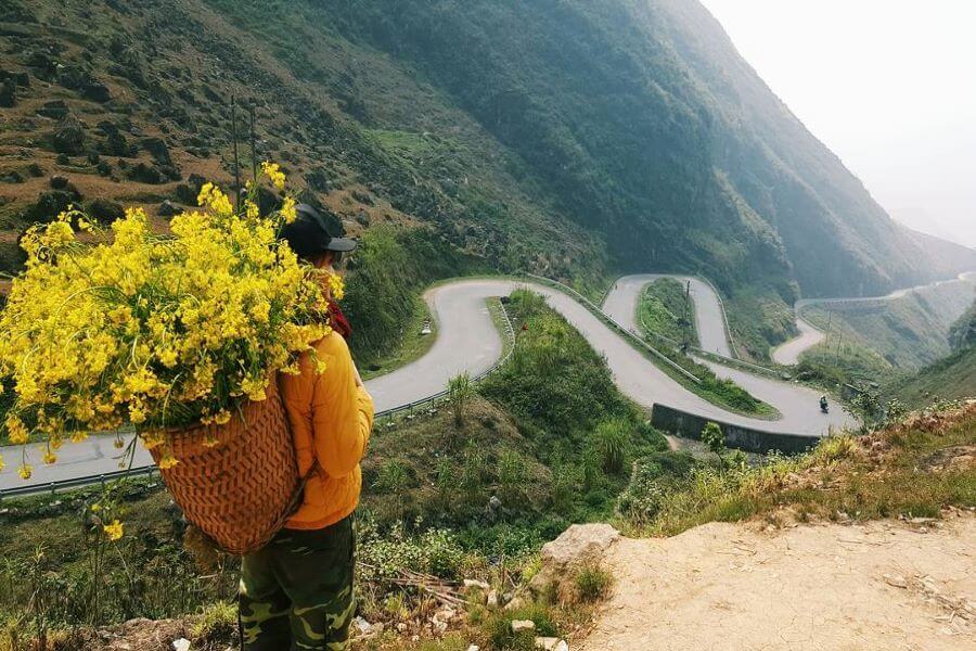
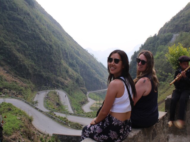
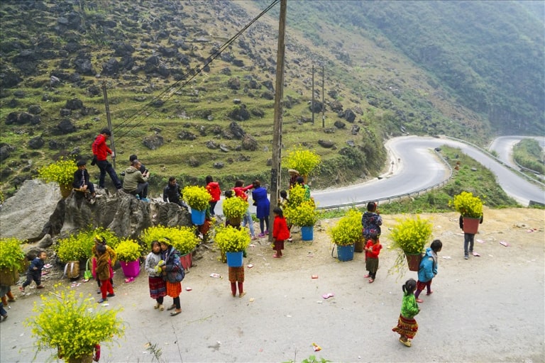
1. Stunning Curves for Photography
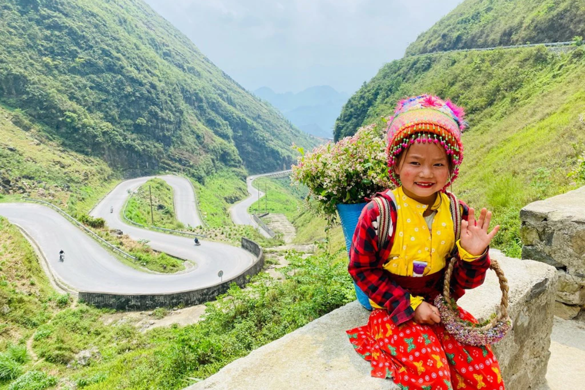
Tham Ma slope features a series of winding bends that look spectacular from above. Many travelers stop at viewpoints to take drone shots or panoramic photos capturing the serpentine road cutting through the limestone mountains.
2. Gateway to the Karst Plateau
For many visitors, Tham Ma slope marks the transition into the most scenic and culturally rich part of the Dong Van Karst Plateau. Conquering this slope feels like entering another world, filled with dramatic peaks and colorful ethnic villages.
3. Adventure and Adrenaline
For motorbike riders, Tham Ma is both a challenge and a thrill. The slope requires careful control, but completing it gives riders a sense of accomplishment and sets the tone for the adventure ahead.
4. Cultural Encounters
Around Tham Ma slope, you may encounter ethnic minority people such as the Hmong, Tay, or Dao. Children in traditional clothes often wave at travelers, adding charm to the journey.
Best Time to Visit Tham Ma Slope
The best time to travel on the Ha Giang Loop, and particularly Tham Ma slope, is from September to November and March to May.
-
September – October: Golden rice terraces in Hoang Su Phi and clear skies.
-
November: Buckwheat flowers bloom across Dong Van and Sung La Valley.
-
Spring (January – March): Peach and plum blossoms paint the mountains.
Avoid traveling during heavy rains (June – August) because the slope can be slippery and dangerous.
How to Get There
From Hanoi to Ha Giang
-
By bus: Overnight sleeper buses run daily from Hanoi to Ha Giang city (6–8 hours).
-
By motorbike: Some adventurous travelers ride from Hanoi, but the distance is nearly 300 km.
From Ha Giang City to Tham Ma Slope
From Ha Giang city, follow National Highway 4C toward Quan Ba, Yen Minh, and Dong Van. Tham Ma slope is located between Yen Minh and Pho Cao, about 100 km from Ha Giang city.
Travel Tips for Conquering Tham Ma Slope
-
Ride carefully: The curves are sharp, so maintain low speed and stay alert.
-
Check your motorbike: Ensure brakes, tires, and fuel are in good condition.
-
Stop at safe points: There are designated viewpoints for photography—avoid stopping in the middle of the road.
-
Travel with companions: It is safer and more enjoyable to ride in groups.
-
Hire a local guide: If you’re not confident in driving, consider joining a Ha Giang Loop tour with an experienced guide.
Nearby Attractions to Combine With Tham Ma Slope
-
Dong Van Old Quarter: A historic town with French-Hmong architecture and vibrant night markets.
-
Lung Cu Flag Tower: The northernmost point of Vietnam, symbolizing national pride.
-
Ma Pi Leng Pass: One of the most spectacular mountain passes in Vietnam, overlooking the emerald Nho Que River.
-
Vuong Family Palace (Hmong King’s Palace): A cultural heritage site reflecting the history of the Hmong people.
-
Sung La Valley: Famous for buckwheat flowers and traditional houses.
Why Tham Ma Slope Should Be on Your Itinerary
Travelers who ask about the Ha Giang Loop highlights often hear about Ma Pi Leng Pass or Lung Cu Flag Tower, but Tham Ma slope deserves equal recognition. It is not just a road but a living symbol of Ha Giang’s culture, history, and adventure spirit. Conquering its winding curves is like passing an initiation into the wonders of the Dong Van Karst Plateau.
Conclusion
So, what makes Tham Ma slope so special? It combines history, culture, and breathtaking natural beauty. Once a test of horse endurance, today it challenges travelers with its steep curves and rewards them with unforgettable scenery. Whether you are a photographer, adventurer, or cultural explorer, Tham Ma slope is a must-see on your Ha Giang journey.
From thrilling motorbike rides to cultural encounters and stunning landscapes, this slope is more than a road - it is the gateway to the authentic heart of northern Vietnam. Plan your adventure today! For more details and personalized support, contact Thelooptours Hotline: +84329196074.