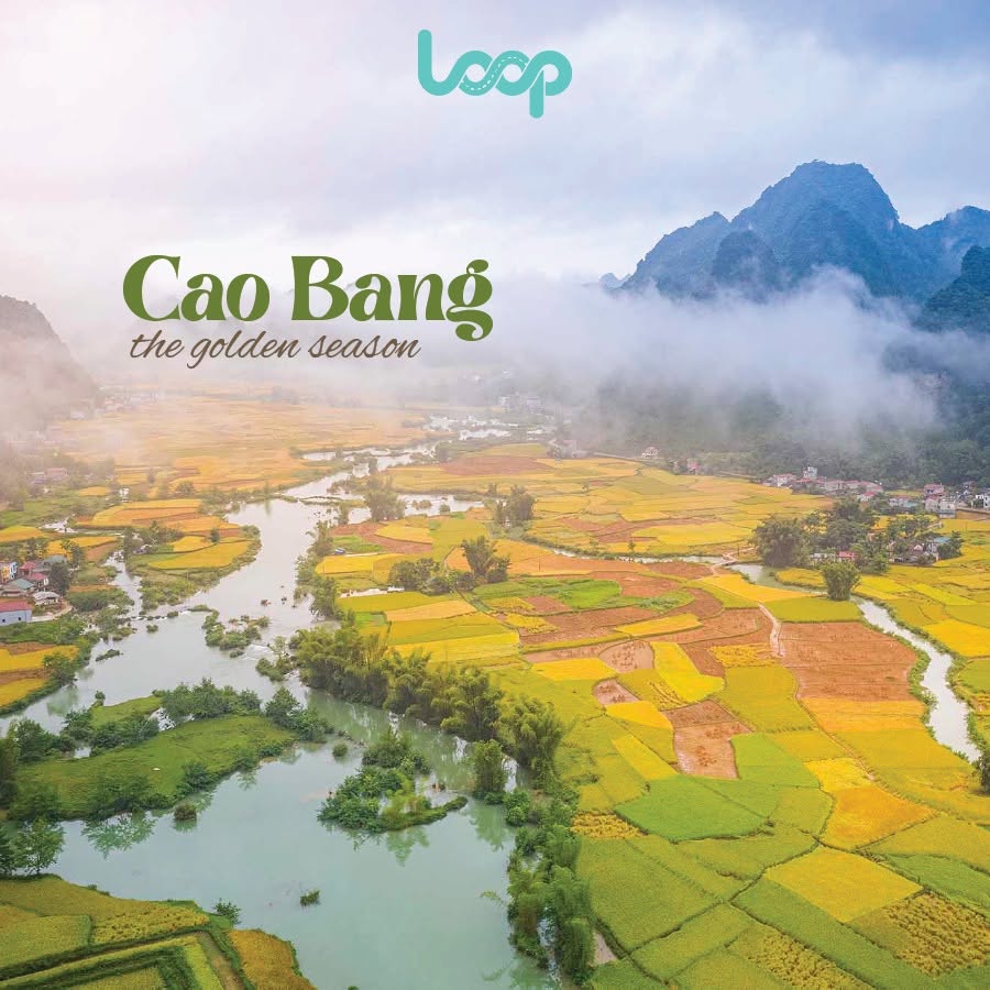
Nestled in the northeastern region of Vietnam, Cao Bang is a hidden gem boasting dramatic landscapes, historical significance, and rich cultural diversity. From towering limestone mountains to stunning waterfalls, this province offers an unparalleled travel experience. To fully embrace the charm of Cao Bang, the Cao Bang Loop Map provides an ideal itinerary that ensures you won’t miss the best sights. Let’s explore this loop map and understand why it’s a must for adventurers.
Where is Cao Bang?
Cao Bang is a northern province of Vietnam, bordering China and located approximately 280 kilometers (174 miles) from Hanoi. Renowned for its karst topography and lush greenery, it offers a pristine escape from urban life. Cao Bang is also home to historical landmarks such as Pác Bó, where President Ho Chi Minh lived during the revolutionary period, making it a destination that combines natural wonders with cultural heritage.
Which Vehicle is Best for Traveling Cao Bang Loop Map?
The Cao Bang Loop is a popular route for adventurers seeking a scenic journey through the rugged terrains of northern Vietnam. Choosing the right vehicle is crucial for enjoying this trip:
-
Motorbike: The most common choice among travelers, a motorbike offers flexibility, allowing you to explore hidden spots and immerse yourself in the breathtaking surroundings. Make sure to rent a reliable bike and wear safety gear.
-
Car: For families or groups, renting a car ensures comfort and protection from weather elements. It’s also a safer option for those less experienced with riding motorbikes on winding mountain roads.
-
Tour Bus or Private Driver: If you prefer a guided experience, a tour bus or private driver can take the stress out of planning while ensuring you visit the key attractions.
Cao Bang Loop Map
The Cao Bang Loop is a circular route that typically starts either from Hanoi or Cao Bang City. Both options offer flexibility depending on your travel plans. Below is a detailed breakdown of the loop with suggested stops and highlights.
Route part 1: Hanoi to Cao Bang City
The journey from Hanoi to Cao Bang City spans approximately 280 kilometers (174 miles). It typically takes around 6–7 hours to complete by car or bus. This route offers a smooth introduction to the adventure that lies ahead. Upon arrival in Cao Bang City, it's best to rest and prepare for the exciting exploration of the loop starting the next day.

Route part 2: Cao Bang City to Trung Khanh (Trùng Khánh)
The second leg of the journey takes you from Cao Bang City to Trung Khanh, where several stunning attractions await.
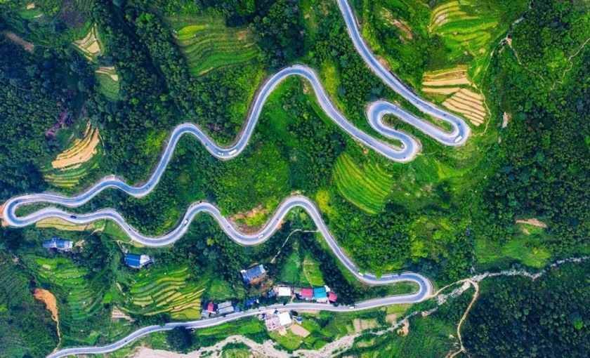
Ma Phuc Pass (Đèo Mã Phục)
Situated about 22 kilometers (14 miles) from Cao Bang City, this iconic mountain pass features winding roads surrounded by limestone peaks and vibrant rice fields. It is a perfect spot to take a break and capture some incredible photos of the scenic landscape. For an overnight stay, Trung Khanh Town offers cozy local homestays or guesthouses.
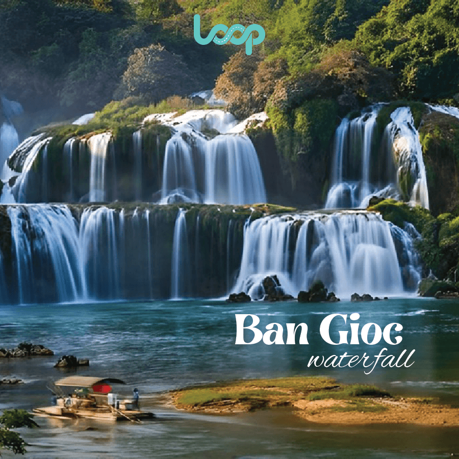
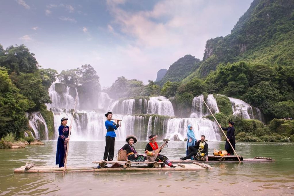
Ban Gioc Waterfall (Thác Bản Giốc)
Located approximately 20 kilometers (12 miles) from Trung Khanh, Ban Gioc Waterfall is the largest waterfall in Southeast Asia. This breathtaking natural wonder lies on the Vietnam-China border, with cascading waters creating a spectacular sight. Visitors can take a bamboo raft ride to get closer to the falls and soak in the serene atmosphere.
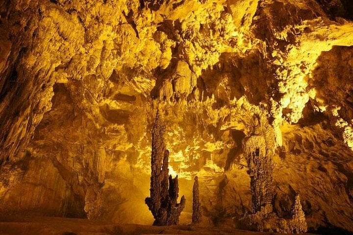
Nguom Ngao Cave (Động Ngườm Ngao)
Just 3 kilometers (1.8 miles) from Ban Gioc Waterfall, Nguom Ngao Cave is a fascinating limestone formation with awe-inspiring stalactites and stalagmites that have formed over thousands of years. A visit to the cave is an excellent complement to the Ban Gioc Waterfall, making for a full day of exploration.
Trung Khanh Chestnut Forest (Rừng hạt dẻ Trùng Khánh)
This area is famous for its lush chestnut forests, a significant part of Trung Khanh’s cultural and natural identity. Located near the town, these forests produce the renowned Trung Khanh chestnuts, known for their large size and sweet, nutty flavor. If visiting in the harvest season (September to November), you can witness locals gathering chestnuts and even taste them freshly roasted. This stop offers a unique glimpse into the local agricultural lifestyle.
Route part 3: Trung Khanh to Quang Uyen (Quảng Uyên) → Thang Hen Lake (Hồ Thang Hen)
From Trung Khanh, the journey continues to Quang Uyen Town and Thang Hen Lake, offering both cultural and natural experiences.
Quang Uyen Town (Thị trấn Quảng Uyên)
About 35 kilometers (22 miles) from Trung Khanh, Quang Uyen is a small town known for its traditional knife-making craft in the village of Phuc Sen (Phúc Sen). Visitors can watch skilled blacksmiths at work and purchase a handmade knife as a unique souvenir. Local guesthouses or homestays in Quang Uyen provide excellent options for an overnight stay.
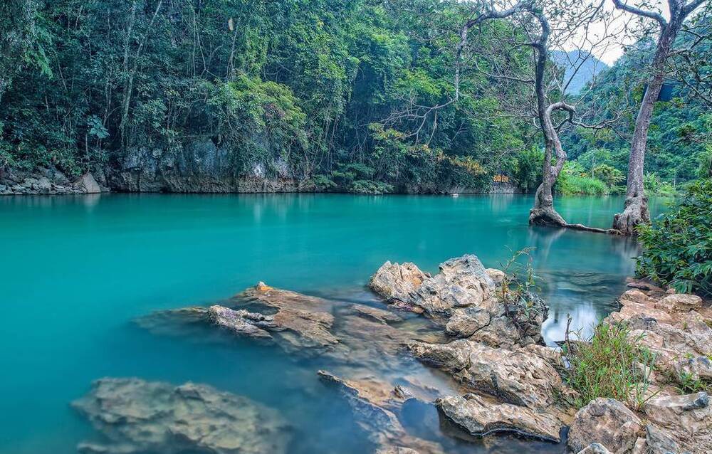
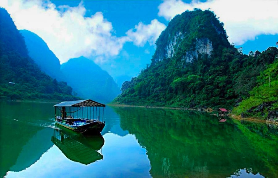
Thang Hen Lake (Hồ Thang Hen)
Roughly 30 kilometers (18 miles) from Quang Uyen, Thang Hen Lake is a serene freshwater lake surrounded by lush green mountains. Its tranquil beauty makes it ideal for photography and peaceful reflection. Early mornings are especially magical, with mist rolling over the water, creating an ethereal atmosphere.
Lung Pan Bamboo Forest (Rừng trúc Lũng Pán)
From Quang Uyen, continue your journey to Lung Pan Bamboo Forest, located approximately 70 kilometers (43 miles) away. Given the long distance, it’s advisable to pack some food and water for the trip. Additionally, exercise caution if traveling during the rainy season, as the roads can become slippery and challenging to navigate.
Located in Lung Pan Village, this enchanting bamboo forest resembles a scene from a classic martial arts movie, reminiscent of the iconic bamboo fights in "House of Flying Daggers" (Thập diện mai phục).
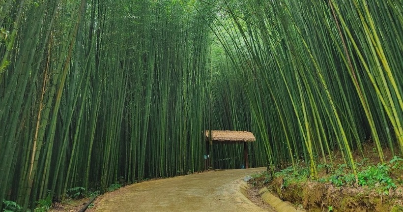
The towering bamboo sways gently with the breeze, creating a mesmerizing interplay of light and shadow that evokes a cinematic sense of mystery and romance. The serene and shaded environment is perfect for a leisurely walk or photo session, immersing visitors in a setting that feels straight out of a legendary tale.
The forest is especially captivating in the morning when sunlight filters through the dense canopy, casting golden rays and enhancing its magical atmosphere. This area also provides a chance to engage with the local Dao community and learn about their culture, adding a rich layer of authenticity to your visit.
Route part 4: Lung Pan Bamboo Forest → Pac Bo Historical Site (Khu di tích Pác Bó)
The final route takes you to the historic Pac Bo area before returning to Cao Bang City.
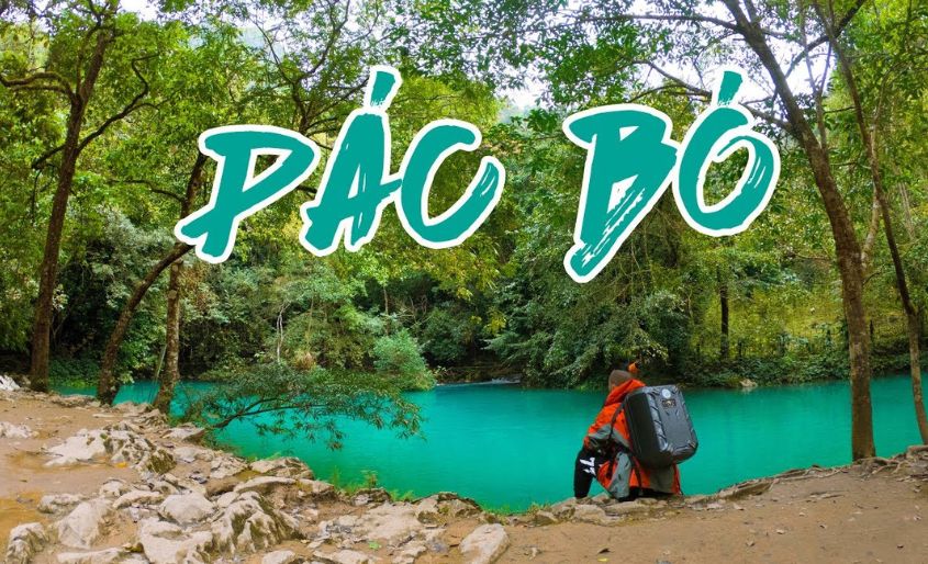
Pac Bo Historical Site (Khu di tích Pác Bó)
After Lung Pan, head toward Pac Bo Historical Site, which is approximately 110 kilometers (68 miles) away. This historical site is where President Ho Chi Minh lived and worked upon returning to Vietnam in 1941. Key attractions include Lenin Stream (Suối Lê-nin) and Coc Bo Cave (Hang Cốc Bó), which provide a glimpse into Vietnam’s revolutionary past. It’s recommended to bring light snacks and water for the short hikes in this area.
After visiting Pac Bo, return to Cao Bang City to rest or continue your journey back to Hanoi.
Conclusion
The Cao Bang Loop Map offers an unforgettable adventure through northern Vietnam’s stunning landscapes, rich culture, and historical landmarks. Whether you’re drawn to the majestic Ban Gioc Waterfall, the tranquility of Thang Hen Lake, the cultural richness of Trung Khanh’s chestnut forests, or the mystical beauty of Lung Pan’s bamboo forest, this loop is perfect for nature lovers, history enthusiasts, and adventure seekers alike. If you have any questions or need further assistance in planning your journey, don’t hesitate to contact us via Hotline: +84329196074. Happy travels!